When the Map Isn't the Territory: How Digital Technologies Reveal Hidden Vulnerabilities in Disaster Planning
June 2, 2026
Grantee | The Trustees of Columbia University in the City of New York (Awarded in 2025 First Quarter)
People were desperate for onigiri. During the 2011 Great East Japan Earthquake and Tsunami, evacuated residents tweeted their locations and searched online for food distribution points. Meanwhile, those same supplies sat unused elsewhere, their distribution based on pre-planned maps that didn't match the reality on the ground.
 "You may remember that during 3.11, there was a mismatch between emergency goods supply and demand," recalls Masahiko Haraguchi, a disaster researcher now at Columbia University's Department of Earth and Environmental Engineering, and a Fellow in the United States-Japan Foundation's US-Japan Leadership Program (USJLP 2022, 2023). "Some affected people didn't get emergency food like onigiri. However, people were tweeting and searching online for where to get food."
This wasn't a failure of goodwill; it was a failure of information. And it revealed something fundamental: the map wasn't matching the territory.
The Problem: Static Plans for Dynamic Disasters
 Haraguchi, who volunteered in Tohoku after 3.11 and later worked in the World Bank's disaster division, kept encountering the same issue. "I realized government disaster plans were a bit static," he explains.
What does "static" mean? "It means they rely on a few limited scenarios," Haraguchi says. "For example, an official disaster plan of a megacity might assume that if an earthquake happens in the daytime, people are commuting. If it happens at night, office areas are empty. These are simple assumptions."
But reality is more complex. Populations change constantly: hour by hour, weekday versus weekend, summer versus winter. "Near coastal areas, many people come to the beach in summer, but not in winter," Haraguchi notes. A plan that treats Tokyo Station the same at 3:00 PM Tuesday as 8:00 PM Sunday is planning for an average that never exists.
The consequence? "Previous disaster planning focused on the majority population, missing the needs of vulnerable populations."
Seeing Cities More Clearly through Data and Digital Twins
The solution did not come from a single technology, but from integrating multiple digital approaches. Working with collaborators, such as Professor Naohiko Kohtake, a computer scientist from Keio University and his lab members, and Professor Liao Kuei-Hsien, an urban planner from National Taipei University, Haraguchi combined disaster expertise with digital technologies and mobility data to better understand how populations move across cities and time.
 Advances in digital twin technologies have opened new potential for simulating different disaster scenarios. "Digital Twin is a technology that has advanced over the last five years," Haraguchi explains digital twins in this way: "It means replicating a physical system in the digital world: cities, buildings, or even human bodies. For city planning, instead of doing a 'social experiment' in the real world, we can replicate the city in data and simulate everything there."
For example, just as doctors can create a digital replica of your heart to test medications before prescribing them, urban planners can create a digital replica of a city to test disaster responses under different conditions.
The power lies in specificity. "If we use smartphone data, we can estimate what kind of people are actually around Tokyo Station at 3:00 PM on a weekday versus a weekend. We can see how populations differ from time to time or seasonally. We can diagnose what is really happening in terms of human mobility hourly, daily, and seasonally. That is dynamic."
The Equity Revelation: Who Gets Left Behind
 When we zoom in with high-resolution data, we see that cities are not homogeneous. Different people occupy different spaces at different times, and planning must reflect that reality.
Consider Haraguchi's New York City research, led by Dr. Mengling Qiao. "In Manhattan, people can easily switch mobility modes. If the subway stops, they take a taxi. But in areas with marginalized socioeconomic conditions, like parts of the Bronx, Brooklyn, or Queens, people have fewer options. This data shows us what kind of transportation planning we should aim for to meet the needs of marginalized communities."
 This research into urban vulnerability is further developed in the study, "Machine learning unveils temperature and mobility as critical predictors of urban crime in New York City (2008–2022): insights for sustainable urban systems." The paper uses data-driven modeling to show how climate factors and transit patterns affect safety, offering a framework for more equitable and climate-resilient urban planning. A summary of the findings and their implications for sustainable urban systems is available here.
Different populations also search for different things during disasters. "When a heavy rainfall event happened near Tokyo Station, many business people searched online for 'train delays.' But people who are pregnant or elderly searched for different terms, like 'how to take a rest' or 'how to get help getting home."
Vulnerability isn't just about who you are, but what you need in a specific moment, and traditional planning systematically misses these differentiated needs.
Cross-National Collaboration: Bridging More Than Borders
This work required bridging different institutional cultures. In Japan, research collaborations often emphasize careful coordination with deep expertise developed through long-term relationships, personal and institutional. In the U.S., teams tend to prioritize open exchange, rapid iteration, and willingness to challenge assumptions. For Haraguchi, navigating these differences ultimately strengthened the research. Combining these approaches produced research that neither side could have developed alone.
This sort of cross-cultural and cross-disciplinary work is one of the features of Haraguchi’s proposal that was so exciting. "There are not many funding sources that support US-Japan collaborative research," Haraguchi emphasizes. "The Foundation's support allowed us to scale up our previous project. This investment has already gotten impressive results with international visibility and multiple peer-reviewed articles already ranked in the top 2% most-referenced studies worldwide, including “Assessing governance implications of city digital twin technology” and “Human mobility data and analysis for urban resilience.” Rigorous and impactful scholarship was necessary, but only the beginning; the real test would be whether those findings could transform how communities actually prepare for and respond to disasters.
From Research to Co-Creation
The most significant shift is happening now, as the project moves from producing research to devising and implementing solutions.
"As the project progressed, we became increasingly committed to developing the more practical applications of our work,” Haraguchi explains. "We are interested in a research style called 'co-production' or 'co-creation.' This means researchers and practitioners work together from the beginning to solve actual social problems. Previously, we produced papers, and stakeholders improved their plans separately. This new approach requires us to produce one outcome together."
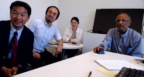
From left to right: Naohiko Kohtake (Keio University), Masahiko Haraguchi (Harvard University),
Mengling Qiao (Columbia University), Upmanu Lall (Columbia University)
Through Keio University, the team connected with a major private-sector real estate developer responsible for critical business districts in central Tokyo. "They have an urgent need to know how to respond to big disasters like earthquakes. We met with practitioners who manage disaster plans, not only researchers, but practitioners, and they shared their perspectives so we could tailor our research to meet their actual needs."
 Similar partnerships were formed to include collaborations with data and mobility organizations in Japan and the United States, including research teams, major technology firm LY Corporation R&D, municipal governments, and mobility service providers, to analyze large-scale datasets and generate deeper insights into human mobility patterns to improve a disaster plan.
But Haraguchi sees a larger opportunity in this sort of collaboration. "Specifically, we want to empower the NPO or social sector in Japan by increasing their technical expertise. Even if an organization has strong institutional management capacity, such as communications and financial systems, without effective, technical interventions, it can be difficult to address complex problems. We want to work with NPOs in the disaster or environmental sectors to co-produce policy recommendations, enhancing their capacity through the process."
This vision aligns with the United States-Japan Foundation's evolving priorities. As USJF increasingly focuses on strengthening civil society infrastructure, the need for cross-sector collaboration — researchers bringing technical capacity to mission-driven nonprofits — becomes critical on a range of issues, including shrinking cities, aging infrastructure, aging-related health risks, and resource inefficiency. Addressing these requires high-level research as well as mechanisms for translating that research into organizational capacity and community action.
The onigiri problem from 3.11 wasn't ultimately about rice balls. It was about the gap between what helpers assumed people needed and what people actually needed. "Since 3.11, the Japanese government and research institutes have set up platforms to collect social media data," Haraguchi notes. But the next frontier isn't just collecting data; it's ensuring organizations closest to vulnerable communities have the capacity to use it.
That's when the map finally matches the territory.

